Scientists find a “yellow brick road” thousands of feet below the sea
A deep-sea expedition has uncovered a continuous band of yellow rock fractured into brick-like blocks nearly 10,000 feet below the ocean surface.
That ordered pattern forces a rethink of how volcanic terrain can fracture and persist under extreme pressure and long isolation.
Where the road appeared
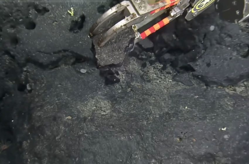
The discovery sits atop the Liliʻuokalani Ridge, a submerged volcanic chain northwest of Hawaii, where a flat, yellow-toned surface interrupts rough seafloor terrain.
While surveying the ridge, the Ocean Exploration Trust documented the formation through high-resolution video captured by a remotely operated vehicle.
The footage shows the surface breaking into near-rectangular segments, creating a visual pattern that stands apart from surrounding rock and sediment.
That visual anomaly marks a narrow but revealing window into the ridge’s volcanic history, setting up the need to explain how such order formed underwater.
The rock behind the pattern
Geologists on the mission treated the rectangles as a clue, and they traced them to volcanic debris.
The surface came from hyaloclastite, volcanic fragments formed when lava hits seawater and shatters fast.
High-energy eruptions can shower glassy shards that settle in layers, then cement into a hard blanket over time.
That geology can fool the eye, so explorers treat neat shapes as evidence of forces, not handiwork.
How fractures formed
Right angles grabbed attention because cooling rock usually cracks in messy ways, yet this patch broke with order.
Thermal stress built each time lava warmed the surface, then contracted as it cooled, opening fractures at crisp corners.
“The unique 90-degree fractures are likely related to heating and cooling stress from multiple eruptions at this baked margin,” according to a Nautilus Live caption.
That kind of cracking preserves a timeline of eruptions, and it helps geologists link separate flows to one ridge.
Light reveals texture
Under the lights, the yellow surface seemed dry because little loose mud covered it, leaving the rock texture clear.
Hardened volcanic fragments formed a firm crust, so the camera lights reflected off sharp edges instead of soft ooze.
The site sat near the top of an underwater volcano, where earlier eruptions piled fragments into a flat terrace.
That smooth terrace made the brick pattern easier to spot, but it still represented a tiny slice of the ridge.
Deep-sea technology
Reaching the ridge required a robotic vehicle with lights and cameras, since no human can work at that depth.
Engineers sealed electronics inside thick housings because pressure rises fast underwater and can crush exposed gear.
Operators steered with joysticks and screens, adjusting altitude and speed until the camera skimmed just above the rock.
Even sharp video can mislead without scale, so scientists compared the blocks with nearby pebbles and ripples.
Life on rocky slopes
These seamounts, underwater mountains built by volcanoes, offer rare hard surfaces where deep animals can anchor and grow.
Around many underwater mountains, currents keep rocks clear and carry food that drifting animals can grab.
“Our exploration of this never-before-surveyed area is helping researchers take a deeper look at life on and within the rocky slopes of these deep, ancient seamounts,” said Ocean Exploration Trust researchers with the Nautilus Exploration Program.
By sampling rock and watching the slopes, researchers can map where small organisms live and track changes over decades.
Conservation beneath the sea
The ridge sits inside Papahānaumokuākea Marine National Monument, a protected Pacific expanse northwest of Hawaii and larger than all U.S. national parks combined.
Federal and state managers treated the area as a fully protected conservation zone, shaping where ships can work.
That protection matters because mapping and camera work must fit conservation goals, not just scientific curiosity or headlines.
Even with rules in place, much of the seafloor remains unknown, so managers still lack basic maps.
Mapping the unseen ocean
A 2025 estimate counted how much of the deep seafloor has appeared in human video so far.
Using public records, the authors put visual coverage between 0.0006 and 0.001 percent since 1958.
Even the higher number equals about 1,476 square miles, which means cameras have barely touched Earth’s largest habitat.
That scarcity makes every clear clip valuable, but it also leaves huge gaps in global plans for conservation.
Watching science in real time
OET treated the yellow road moment as part of a bigger plan to open deep-ocean research to outsiders.
Satellite links send video and audio to shore, so scientists and classrooms can follow each move from land.
That approach lets specialists join without flying to the ship, which saves time and spreads expert attention.
Still, cameras capture only what the vehicle passes, so unseen ridges can stay blank until funding returns.
Guiding future exploration
The yellow bricks turned out to be cracked volcanic crust, and the surprise pushed researchers to look harder at hidden ridges.
More cameras, broader access, and clearer maps will decide whether similar finds stay viral moments or become lasting science.
—–
Like what you read? Subscribe to our newsletter for engaging articles, exclusive content, and the latest updates.
Check us out on EarthSnap, a free app brought to you by Eric Ralls and Earth.com.
—–
First Appeared on
Source link

