Scientists Map a Previously Invisible Fault Structure That May Trigger a Major Earthquake
A new 3D model is giving scientists a clearer look at what’s happening deep beneath the Marmara Sea and where the next major earthquake near Istanbul might start. By mapping underground rock properties, the study highlights zones where stress could already be building along the North Anatolian Fault.
Türkiye sits at the meeting point of the Eurasian, African, Arabian, and Anatolian tectonic plates. That setup has led to many destructive earthquakes over time, including the 1939 Erzincan earthquake, which killed more than 30,000 people.
Since then, scientists have noticed a pattern. Major earthquakes seem to move westward along the North Anatolian Fault (NAF). That shift has put the spotlight on the zone beneath the Marmara Sea, which hasn’t produced a large quake in over 250 years.
A Quiet Zone That May Not Be So Quiet
At first glance, the Marmara Sea segment of the fault looks calm. But according to the study published in Geology, that long quiet period could actually mean stress has been building up underground.
Researchers have struggled to get a clear picture of this offshore fault system. As stated by the study, that lack of detail has made it harder to figure out exactly where a future earthquake might begin or how it could affect a city like Istanbul. And that uncertainty has been hanging over the region for years.
Using Earth’s Signals To See Underground
To get around this, a team led by Dr. Yasuo Ogawa from Science Tokyo and Dr. Tülay Kaya-Eken from Boğaziçi University built a full 3D electromagnetic model of the area.
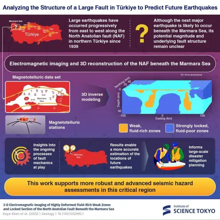
According to the researchers, they used data from more than 20 magnetotelluric stations, which record natural changes in Earth’s electric and magnetic fields. With a method called 3D inversion, they turned those signals into a map of underground electrical resistivity, reaching tens of kilometers below the seafloor.
“The first three-dimensional inverse modeling performed on a magnetotelluric dataset of the MS (Marmara Sea)has unveiled localized weak and locked fault segments along this shear deformation zone,” the authors said.
It’s not a direct image, but it gives a surprisingly detailed view of structures that can’t be seen otherwise.
Where Strong And Weak Rocks Meet, Stress Builds
What the model shows is a mix of low-resistivity and high-resistivity zones. As Ogawa explained, low-resistivity areas tend to contain fluids and are mechanically weaker, while high-resistivity zones are stronger and more locked.
“We believe the resistive anomalies observed signify regions of stress accumulation, shedding light on the ongoing processes of fault mechanics at play in this critical region,” he said.
Based on the research, the most likely places for future earthquakes to start are the boundaries between these zones or along the edges of the most rigid areas. These spots seem to concentrate stress, making them key points along the fault.
“Our results can be used to estimate the location and potential magnitude of future megathrust earthquakes, with significant implications for disaster prevention and mitigation,” he added.
But the result does not predict exactly when the next earthquake will happen. That is something scientists have been trying to pin down for quite a long time now, as determining exactly where a rupture may begin remains a persistent challenge, particularly in complex and poorly imaged fault systems.
First Appeared on
Source link

