Hurricane Melissa Forecast: Catastrophic, Historic Jamaica Strike Begins
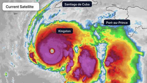
Current Satellite Image
(The highest cloud tops, corresponding to the most vigorous convection, are shown in the dark red and pink colors. Clustering, deep convection around the center is a sign of a healthy tropical system.
)
Hurricane Melissa is now a Category 5 storm as it begins a catastrophic, historic, multiday strike on Jamaica with life-threatening flash flooding, landslides, destructive winds and storm surge.
Melissa’s torrential rain will also trigger catastrophic flooding in Haiti, and it will later strike eastern Cuba and parts of the Bahamas.
(MORE: Track Melissa With These Maps | Melissa Could Be Jamaica’s Strongest Landfall)
Happening Now
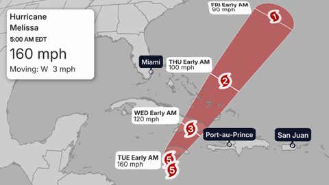
Hurricane Melissa’s center is just over 100 miles south-southwest of Kingston, Jamaica. The hurricane’s forward speed is roughly 5 mph, which is the main driver behind some of its biggest threats.
Bands of heavy rain and tropical storm conditions have arrived in Jamaica, while heavy rain is also streaming into southern Haiti.
Melissa underwent extreme rapid intensification from a tropical storm to Category 4 hurricane in just 24 hours from Saturday morning through Sunday morning. It then became the third Category 5 hurricane of the 2025 Atlantic hurricane season early Monday morning.
(MORE: Rapid Intensification Is More Common Than You Think)
A Category 5 Floodmaker
Melissa’s slow movement over the next several days will lead to prolific rainfall in parts of Haiti and Jamaica.
(MORE: Why Slow-Moving Storms Are The Worst)
The National Hurricane Center is warning that up to 40 inches of rain could fall in southern Hispaniola and Jamaica through Wednesday.
That torrential rainfall is likely to trigger catastrophic, life-threatening flash flooding and landslides in Jamaica and Haiti, especially in hilly and mountainous terrain, according to the National Hurricane Center.
In addition to the rainfall flood threat, the NHC is forecasting a storm surge of 9 to 13 feet above ground level east of where Melissa is forecast to landfall along the southern coast of Jamaica early Tuesday.
This surge could affect parts of Jamaica’s capital city, Kingston, including Norman Manley International Airport, as Yale Climate Connections’ Jeff Masters noted.
In eastern Cuba, up to 20 inches of rain could trigger potentially catastrophic flash flooding and mudslides, and a life-threatening storm surge of 6 to 9 feet above ground level could occur along the southeast Cuban coast with landfall.
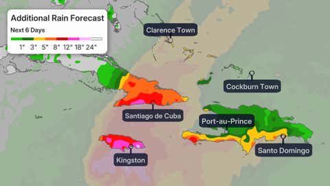
Additional Rain Forecast
(This should be interpreted as a broad forecast of where the heaviest rain may fall and may shift based on the forecast path of the tropical cyclone. Higher amounts may occur where bands of rain stall over a period of a few hours. )
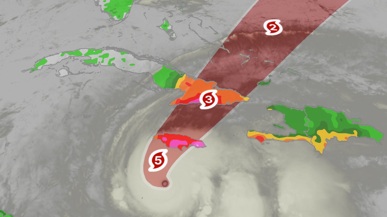
Forecast Track, Intensity
Melissa will slowly curl northeastward and make landfall over Jamaica Tuesday, then push into eastern Cuba Tuesday night or early Wednesday, then quickly through the southeast Bahamas or Turks and Caicos Wednesday. Melissa could then track close to Bermuda Thursday night or early Friday.
Though both Category 4 and 5 hurricanes are intense and dangerous, Melissa could landfall in Jamaica at Category 5 intensity Tuesday, then could still be a major hurricane at the time of eastern Cuba’s landfall.
According to NOAA’s historical database, though eight other Category 4 or 5 hurricanes have tracked within 60 nautical miles of Jamaica, there is no record of such an intense hurricane making a landfall, there. Only two other Category 5 hurricanes have previously tracked this close to Jamaica since the mid-19th century: Allen in 1980 and Ivan in 2004.
Current Status, Forecast Path
(The red-shaded area denotes the potential path of the center of the tropical cyclone. It’s important to note that impacts (particularly heavy rain, high surf, coastal flooding, winds) with any tropical cyclone usually spread beyond its forecast path.
)
Destructive Wind Danger
According to the National Hurricane Center, destructive hurricane conditions are expected in Jamaica to begin tonight or early Tuesday. The NHC also says winds could be up to 30 percent stronger along windward slopes of mountains and hills.
These winds are capable of “extensive infrastructural damage” as well as “long-lasting power and communication outages” that could leave communities isolated, according to the NHC.
Tropical storm conditions are already being felt in Jamaica, and these winds could last into Tuesday night.
In eastern Cuba, tropical storm winds are expected starting Tuesday, with hurricane force winds arriving Tuesday evening.
And in the southeast Bahamas, Turks and Caicos, tropical storm and hurricane conditions are possible Wednesday.
(MORE: Not Too Late In Season For An Intense Hurricane)
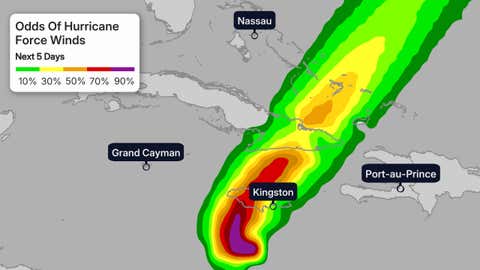
Hurricane Wind Chances
(The contours above show the chance of hurricane-force winds (at least 74 mph), according to the latest forecast by the National Hurricane Center.
)
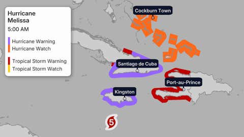
The map below shows the latest warnings in effect for Melissa.
A hurricane warning means hurricane-force winds are expected, and tropical-storm-force winds could persist for longer than a day, in this case.
A hurricane watch means those conditions are possible within 48 hours.
The tropical storm warning means tropical storm conditions are expected by Tuesday in Haiti and Cuba.
Watches And Warnings
(A watch is issued when tropical storm or hurricane conditions are possible within 48 hours. A warning is issued when those conditions are expected within 36 hours.
)
Number 13
Tropical Storm Melissa formed late Tuesday morning, the 13th storm of the 2025 Atlantic hurricane season. By Saturday afternoon, it became the season’s fifth hurricane.
That’s roughly on par with the average date of the 13th storm from 1991 through 2020 (Oct. 25), according to the National Hurricane Center. It’s also one storm shy of the average number of storms for an entire season, 14.
However, it was almost a month later than the average fifth hurricane date of September 28.

The 2025 Atlantic hurricane season names list. Those storm names used up already have check marks next to them.
Melissa is also the first storm of the season to track into the Caribbean Sea. As you can see in the season-to-date tracks map below, most other storms and hurricanes have curled north of the Caribbean Sea this season.
That’s due either to steering winds in the Atlantic, or hostile conditions for development in the Caribbean Sea prior to Melissa.
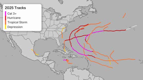
2025 Atlantic Hurricane Season Tracks To Date
Check back with us at weather.com for the latest forecast updates on Melissa, and elsewhere in the tropics.
Jonathan Erdman is a senior meteorologist at weather.com and has been covering national and international weather since 1996. Extreme and bizarre weather are his favorite topics. Reach out to him on Bluesky, X (formerly Twitter) and Facebook.
First Appeared on
Source link

