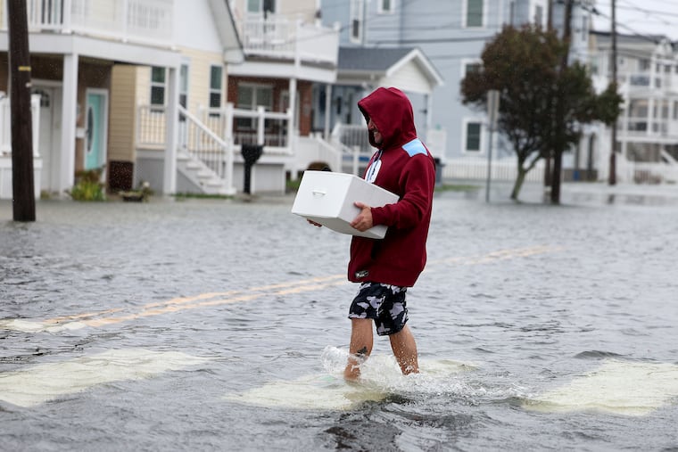
Nor’easter erases more sand from Jersey beachs
While the peculiar holiday-weekend nor’easter spared the Jersey Shore catastrophic flooding, it was the latest episode in a two-month assault on fragile beaches in their 100-year battle with the Atlantic Ocean.
The immediate Philadelphia area got by with modest rains and some wind, but the beaches endured 48 hours of onshore winds that gusted past 60 mph. It was the fifth spell since Aug. 18 of consecutive days with winds from east and northeast, including a six-day stretch that began Sept. 27.
“There hasn’t been much time for natural recovery of the beaches at this point,” said Kimberly McKenna, interim chief of the Stockton University Coastal Research Center, which will be assisting in beach surveys.
Officials in Ocean City and North Wildwood reported significant erosion from the storm that threw a few curves at the meteorologists.
It is unclear how that erosion may exacerbate flooding in future storms. However in this round, no significant injuries or structural damages were reported, despite the gusts and multiple flood tides that inundated roadways.
That said, it will take some time to assess the damages, said Ocean City spokesperson Doug Bergen.
‘We are fortunate,’ Shore officials say
In Wildwood, emergency official Daniel Dunn said, “Overall, we are fortunate that we did not get the major flooding that was projected with the storm.”
And Michael Famularo, acting head of emergency management in Atlantic City, echoed, “The flooding has been less than expected.”
Still, Bergen said his Cape May County town was “expecting substantial erosion across all of its beaches.”
New Jersey’s constant battle with erosion continues
In addition to storms, areas of high pressure, or heavier air, to the north of the region — which usually bring dry conditions — have contributed to the onshore flows, said Patrick O’Hara, meteorologist with the National Weather Service in Mount Holly.
Winds circulate clockwise around the centers of highs so that areas to the south of the center experience winds from the east. Also, when they interact with areas of the low-pressure, or lighter air, of storms, winds intensify.
That interplay was in evidence in August with Hurricane Erin, which stayed hundreds of miles offshore but still generated damaging winds and storm waves.
According to a New Jersey Department of Environmental Protection survey, more than 85% of the state’s beaches endured “minor” to “moderate” erosion from Erin. Among those in the moderate category were the sands of Avalon, Ocean City, Strathmere, and North Wildwood.
Replenishing beaches at the Jersey Shore with federal and state money is a longstanding — and controversial — practice. Its critics hold that taxpayers are subsidizing protection of vacation properties; town officials counter that it’s an economic imperative.
New Jersey beaches have been beneficiaries of more than $733 million in federal beach-protection projects this century, according to data from Howard Marlowe, one of the nation’s most prominent coastal lobbyists. That’s a close second to Florida, which has 10 times the coastline.
However, this fiscal year will mark the first time since at least 2001 — despite anxieties about rising seas in a warming climate and $80 billion worth of real estate on the barrier islands in Jersey alone — that no money has been appropriated for shore projects, he said.
Concerns over the future of Jersey beaches are not new: “The erosions are still in progress, and unless checked will … result in further loss of physical property.” So concluded a team of Garden State experts in a landmark analysis — in 1922.
Jersey beaches will have at least several days to regroup
Come Tuesday the atmosphere will begin shedding the Monday blues, and the rest of the week should be about as good as October gets all over the region.
Highs should be in the low and mid-60s, a few shades below normal, with wall-to-wall sun through Sunday, forecasters say.
For that matter, save for the Monday rain and a gloomy weekend, the weather in Philadelphia was a day at the beach compared to the Shore.
Not that the forecasts were complete busts.
Late last week they called for winds up to 60 mph at the Shore and 40 mph west of the Delaware River.
That worked out fairly well, as a 46-mph gust was recorded at Philadelphia International Airport and 62 mph near the Shore. Atlantic City Electric reported more than 12,000 power outages.
Rains were another matter. Coming into the storm, Philly’s official rainfall total was less than one-fourth of normal, at 0.41 inches for the month The preliminary storm total came in at 0.2 inches.
The forecasts had foreseen widespread amounts of 1 to 3 inches with isolated totals up to 5 inches.
Some areas along the immediate coast did see 2-inch-plus amounts, said Alex DaSilva, storm specialist with AccuWeather Inc.
Heavier rain fell on the southern New England coast, said DaSilva, and that appeared to be the result of a last-minute quirk in the storm’s development.
Rather than one mega-nor’easter, the coastal storm essentially ended up with two centers, resulting in an “elongated” heavy-rain path along the coast, he said.
The weather service’s O’Hara said that if the storm had consolidated, it would have thrown substantial rains inland.
It was a development unforeseen by computer models until the weekend.
Don’t be surprised if something similar happens again soon. The nor’easter season has just begun.
First Appeared on
Source link


