Plowable snow returns to Massachusetts Tuesday. Maps show who might get the most.
Gas up the snow blowers and dig the shovels out of the shed, the first snowstorm of the winter is on the way for Massachusetts and the Boston area on Tuesday.
The WBZ Weather Team is highlighting Tuesday as a NEXT Weather Alert day. In addition, the National Weather Service has issued a Winter Storm Watch on Tuesday for areas north and west of Interstate 95. This includes all of southern Vermont, New Hampshire and Maine as well.
A winter storm watch is typically issued within 48 hours of the start of an event and for areas where 6 inches or more of snow accumulation is possible.
This will be converted to a winter storm warning if the forecast remains the same within 24 hours of the event.
CBS Boston Graphic
This will not be a blockbuster storm. You could technically call it a nor’easter, although the winds in this storm will not be a major factor like most nor’easters.
The other good new is we don’t expect any major coastal issues. No significant flooding, wind damage or outages.
Tuesday snow timeline
This will be a one day event, spanning nearly the entire day Tuesday (after dawn).
The first flakes will fly shortly after dawn and many will see some light snow during the Tuesday morning commute.
Major weather-related traffic issues are not expected through 9 a.m. Tuesday.
CBS Boston Graphic 
By 10 a.m., it will be snowing (or raining in southeast Massachusetts) in all of southern New England.
Roads will quickly become snow-covered north and west of I-95 and travel will steadily deteriorate hour-by-hour.
CBS Boston Graphic 
The Tuesday evening commute will be treacherous with the rain and snow continuing to fall heavily at times.
We expect the rain/snow line to be somewhere in the vicinity of I95, give or take 5-10 miles on either side.
It will be a heavy, wet snow for most in the 128 and 495 belts. Slightly colder temperatures in central and western Massachusetts will make the snow a bit fluffier out that way.
CBS Boston Graphic 
The snow will begin to taper from west to east between 8-11pm with the final flakes exiting the coastline around or just after midnight.
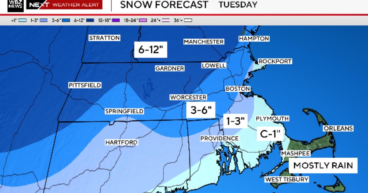
How much snow?
The highest snow amounts will be in the elevated areas of central and western Massachusetts. The snow totals taper off the farther south and east you travel.
6-12″: Berkshires, northern Worcester County, I-495 belt from Marlboro to Haverhill and all areas northwest.
3-6″: Areas in between I-95 and I-495 northwest of Boston, including most of MetroWest. The rain/snow line will reach its farthest northern point somewhere in this area during the afternoon on Tuesday and waffle around for several hours, therefore snow amounts in this region are the most difficult to pinpoint
1-3″: Immediate coastline from Cape Ann to Boston, also northern coastal Plymouth County. These areas will start briefly as snow and then change to rain for the vast majority of the day on Tuesday, finally switching back to snow for the last few hours of the storm
Coating-1″: Most of southeast MA including central and southern Bristol and Plymouth counties down to the Canal. This will likely come at the tail end of the storm as winds veer to the north
Mainly Rain: Cape Cod and the Islands
CBS Boston Graphic 
Since it has been a while, we urge that you make sure that your car is “winterized.”
Might be a good idea to use our winter checklist during the day on Monday if you plan on traveling on Tuesday during the storm.
CBS Boston Graphic 
What’s next?
December is bringing all the winter feels along with it! Looks like a blast of very cold air later this week following a cold front on Thursday.
It will be absolutely frigid Thursday night through Friday with feels like temperatures dipping below zero for the first time this year.
Our next chance of rain or snow looks to arrive on Saturday. More on that storm in the coming days.
First Appeared on
Source link

