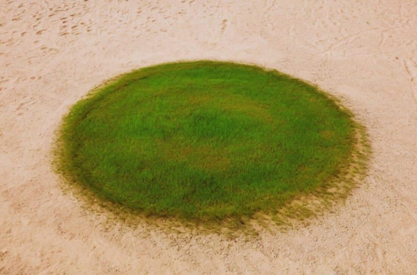
A Perfect Green Circle in the Sand? Astronauts Spot Ancient Lake Hidden in the Saudi Desert
Tucked inside a sunken basin of the Nafud Desert, the town of Jubbah thrives where water once ruled. Surrounded by towering dunes and searing heat, this remote settlement stands out in satellite imagery as a patchwork of vivid green circles, a sign of surprising agricultural life fed by hidden groundwater.
A Town Shielded By Sand And Time
Jubbah’s location within a paleolake basin, measuring approximately12.5 miles long and 2.5 miles wide, has helped it retain a unique microclimate. The nearby Jabal Umm Sinman mountain, which rises to 4,144 feet (1,264 meters), plays a vital role. Its twin-hump silhouette, reminiscent of a resting camel, inspired its name, which translates as “two camel-hump mountain.”As noted in NASA’s Earth Observatory report, the mountain’s bulk creates a “wind shadow,” protecting the town from much of the sand carried by the dominant west-to-east desert winds.
This natural barrier has also helped sustain agriculture. Most of the area’s current farming relies on center-pivot irrigation, forming the distinctive circular fields visible from orbit. Thanks to a subsurface aquifer, the settlement continues to access water even in this hyperarid zone.
Relics Of Early Desert Dwellers
Beyond its agricultural value, Jubbah is also one of Saudi Arabia’s richest archaeological zones. Scattered across the rocky foothills of Jabal Umm Sinman are an estimated 5,500 inscriptions and 2,000 animal engravings, including images of leopards, ostriches, and more than 1,000 camels. These carvings are believed to date back at least 10,000 years.
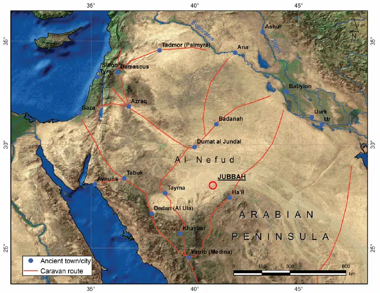
As reported by the same article, the area was likely a waypoint for early humans, thanks to its persistent water supply long after other lakes in the Arabian Peninsula had dried up, around 5,000 years ago. Faint roads visible in satellite imagery are thought to align with paths used by these ancient travelers. Their legacy, etched in stone, forms part of a UNESCO World Heritage Site that also includes rock art sites near Shuwaymis.
The Continent That’s Running Out of Water
Jubbah’s landscape captures a moment in planetary history when the Arabian Peninsula was far greener than today. As climate patterns shifted and desertification took hold, most of the region’s freshwater lakes vanished. The Earth Observatory noted that:
“Jubbah Lake was one of a network of freshwater sources in what was then a more humid environment. Even as the region became more arid, Jubbah Lake likely continued to hold freshwater for some time due to its position amid the groundwater-recharging dunes”
The existence of such sites supports a growing body of research into ancient human migration routes, suggesting that water-rich waypoints like Jubbah may have played a central role in the movement of early populations across arid zones.
First Appeared on
Source link

