How much snow in NYC this weekend? Blizzard, winter storm warnings issued for NJ, NY, CT
NEW YORK (WABC) — A powerful winter storm is expected to deliver the first blizzard to the Tri-State area in almost a decade from Sunday afternoon through Monday morning, with heavy snow, strong winds and hazardous travel likely.
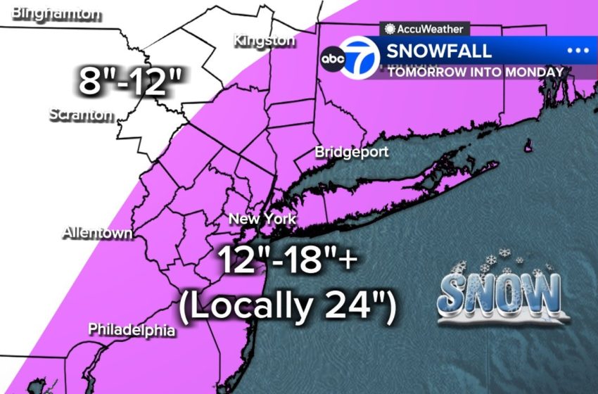
The storm could cripple transportation across the region, with 12 to 18 inches expected across a wide swath, with heavy, wetter snow falling.
Wind gusts topping 50 mph Sunday night into Monday morning could bring down trees and power lines, compounded by the heavy snow, making travel extremely dangerous or even impossible. Power outages and coastal flooding – up to 2.5 to 3 feet during high tides are also concerns, and a Coastal Flood Warning has already been issued.
The storm is poised to be the biggest snow-maker to slam the Tri-State area since the storm of January 2016, which was the biggest snowstorm to ever hit NYC on record. The last time we faced a blizzard warning was in March 2017, so this is a rare event.
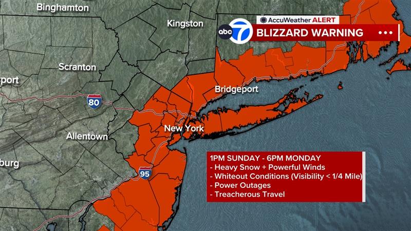
The National Weather Service has issued blizzard and winter storm warnings for New York City and the Tri-State area on Sunday into Monday.
Saturday is the calm before the storm with increasing clouds but dry and mild conditions. Highs reach the mid to upper 40s.
That changes quickly overnight as the powerful coastal storm races up the East Coast. Light snow begins around sunrise Sunday, though temperatures will be just above freezing early on – so the first flakes may struggle to stick and we may have a slushy inch or so by early afternoon. Accumulation piles on through the afternoon as temperatures fall and steadier snow develops.
Blizzard Conditions Possible Sunday Night into Monday
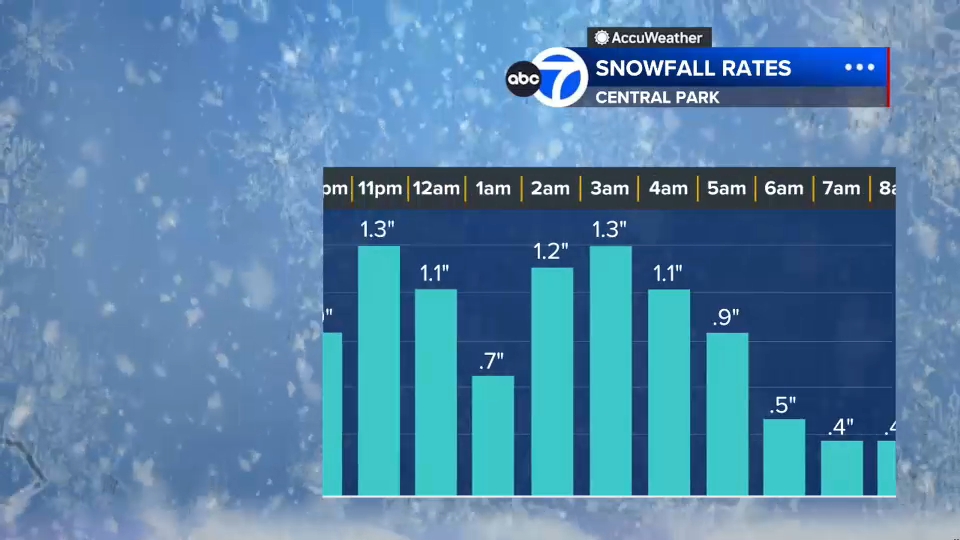
The worst of the storm arrives late Sunday afternoon and lasts through sunrise Monday. Snowfall rates could reach 2-3 inches per hour, with strong winds creating whiteout conditions – especially along the coast. The storm’s central pressure off the coast will rival that of a category 2 or 3 hurricane. This strengthening will collapse in colder air and change all precipitation to heavy snow.
Blizzard Warnings are in effect for:
Long Island
All five boroughs
Westchester and Rockland counties
Coastal Connecticut
Much of New Jersey
A Blizzard Warning means winds or gusts will hit or exceed 35 mph along with blowing snow, with visibility knocked down to 1/4 mile or less for three hours or more.
Winter Storm Warnings cover the rest of the region.
Snowfall Potential
By the time the storm pulls away Monday, much of the area is expected to see 12-18 inches of snow, with locally higher totals over a foot likely across the East End and parts of the Jersey Shore. Some areas could see over 20 inches east and south of New York in heavy bands where to 2 to 3 inches of snow fall for 6 to 8 hours.
Timeline
Saturday: Cloudy and mild; highs in the 40s. Good day for storm prep.
Sunday morning: Light snow develops; limited early accumulation.
Sunday afternoon: Colder; steadier snow begins.
Sunday evening: Monday morning: Peak storm impact. Heavy snow, whiteout conditions, 50+ mph gusts, dangerous travel.
Monday midday: Snow tapers; still windy but improving.
Tuesday: Cold with leftover snow cover.
Midweek: Gradual thaw.
Officials urge residents to finish preparations Saturday and avoid any non-essential travel from Sunday evening through Monday morning.
LATEST ACCUWEATHER FORECAST
AccuWeather Alerts remain in effect through Monday morning. Snowfall projections will continue to be updated as new data comes in.
First Appeared on
Source link

