Hurricane Melissa Forecast: Catastrophic Danger For Jamaica, Haiti
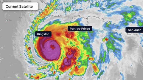
Current Satellite Image
(The highest cloud tops, corresponding to the most vigorous convection, are shown in the dark red and pink colors. Clustering, deep convection around the center is a sign of a healthy tropical system.
)
Hurricane Melissa is rapidly intensifying and could reach Category 5 status ahead of a catastrophic, multi-day strike on Jamaica with life-threatening flash flooding, landslides, destructive winds and storm surge.
Melissa’s torrential rain will also trigger catastrophic, damaging flooding in Haiti, and it will later strike eastern Cuba and parts of the Bahamas.
(MORE MAPS: Melissa Map Tracker)
Happening Now
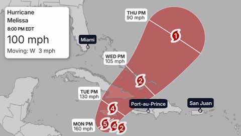
Hurricane Melissa’s center is 130 miles southeast of Kingston, Jamaica. The hurricane’s forward speed is less than 5 mph, which is the main driver behind some of its biggest threats.
According to the National Hurricane Center, Melissa is now rapidly intensifying, as it’s now developing an eyewall in radar imagery from Jamaica’s Meteorological Service.
Outer bands of showers and thundershowers with heavy rain are streaming northward across parts of Jamaica, Hispaniola and Cuba.
A Category 5 Floodmaker
Melissa’s slow movement over the next several days will lead to prolific rainfall in parts of Haiti and Jamaica.
(MORE: Why Slow-Moving Storms Are The Worst)
The National Hurricane Center is warning that up to 40 inches of rain could fall in southern Hispaniola and Jamaica through Wednesday.
That torrential rainfall is likely to trigger widespread, life-threatening flash flooding and landslides, especially in hilly and mountainous terrain.
The National Hurricane Center warned that “extensive infrastructural damage, long-duration power and communication outages, and potentially prolonged isolation of communities” are likely in Jamaica and Haiti.
Heavy rainfall will also likely trigger life-threatening flash flooding and landslides in the Dominican Republic and eastern Cuba.
In addition to the rainfall flood threat, the NHC is forecasting a storm surge of 9 to 13 feet above ground level east of where Melissa is forecast to landfall along the southern coast of Jamaica overnight Monday night or early Tuesday.
This surge could affect parts of Jamaica’s capital city, Kingston, including Norman Manley International Airport, as Yale Climate Connections’ Jeff Masters noted.
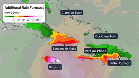
Additional Rain Forecast
(This should be interpreted as a broad forecast of where the heaviest rain may fall and may shift based on the forecast path of the tropical cyclone. Higher amounts may occur where bands of rain stall over a period of a few hours. )
Forecast
Where It May Go
Melissa will drift slowly westward through Monday, then curl northeastward and begin to move faster.
That track will likely bring the core of Melissa over Jamaica Tuesday, then into eastern Cuba later Tuesday or early Wednesday, then quickly through the southeast Bahamas or Turks and Caicos Wednesday.
Beyond that, it’s too soon to tell if Melissa would then become a threat to Bermuda late in the week.
How Strong?
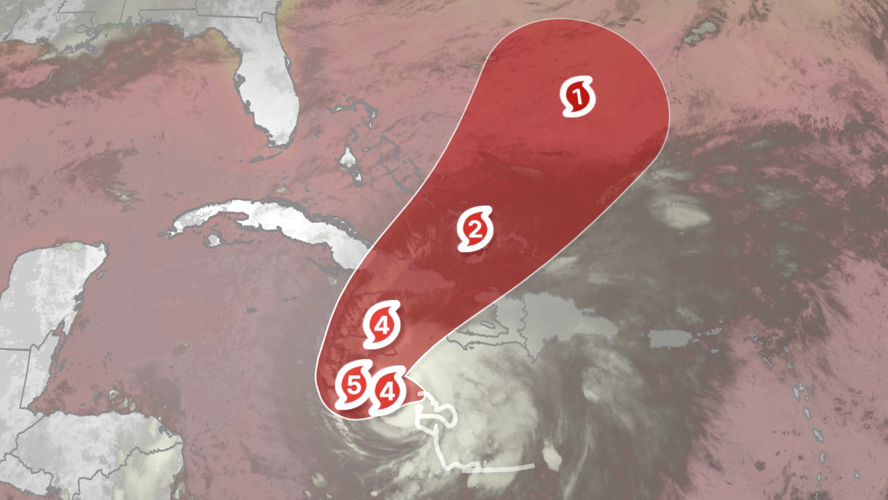
Melissa is now forecast to top out at Category 5 intensity and could hold at least Category 4 intensity at landfall in Jamaica, feeding on an ample supply of warm, deep Caribbean Sea water.
And that could make history.
According to NOAA’s historical database, though eight other Category 4 or 5 hurricanes have tracked within 60 nautical miles of Jamaica, there is no record of such an intense hurricane making a landfall, there.
The current intensity forecast for Melissa is denoted by the Saffir-Simpson Hurricane Wind Scale categories in the forecast path graphic below.
(MORE: Rapid Intensification Is More Common Than You Think)
Current Status, Forecast Path
(The red-shaded area denotes the potential path of the center of the tropical cyclone. It’s important to note that impacts (particularly heavy rain, high surf, coastal flooding, winds) with any tropical cyclone usually spread beyond its forecast path.
)
Wind Danger
According to the National Hurricane Center, hurricane conditions are expected in Jamaica by Sunday or Monday and are possible in eastern Cuba Tuesday into Wednesday.
Tropical storm conditions are expected to move into Jamaica shortly, and these winds could persist for several days once they start.
(MORE: Not Too Late In Season For An Intense Hurricane)
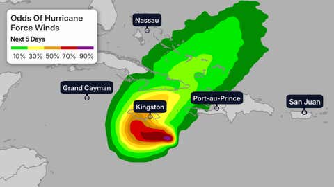
Hurricane Wind Chances
(The contours above show the chance of hurricane-force winds (at least 74 mph), according to the latest forecast by the National Hurricane Center.
)
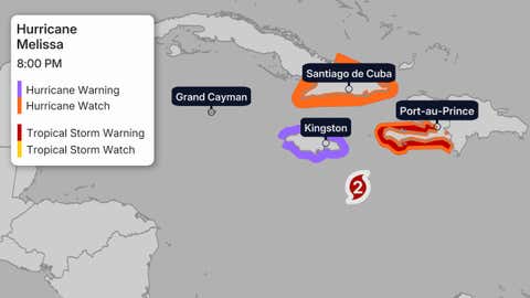
The map below shows the latest watches and warnings in effect for Melissa.
A hurricane warning means hurricane-force winds are expected, and tropical-storm-force winds will move in within 36 hours.
A hurricane watch means those conditions are possible within 48 hours.
A tropical storm warning means tropical storm conditions are expected within the next 36 hours.
These alerts currently cover parts of southern Haiti, Jamaica and eastern Cuba.
According to the National Hurricane Center, these winds, along with the widespread flash flooding, are likely to lead to extensive infrastructural damage, long-duration power and communication outages and potentially prolonged isolation of communities.
Watches And Warnings
(A watch is issued when tropical storm or hurricane conditions are possible within 48 hours. A warning is issued when those conditions are expected within 36 hours.
)
Number 13
Tropical Storm Melissa formed late Tuesday morning, the 13th storm of the 2025 Atlantic hurricane season. By Saturday afternoon, it became the season’s fifth hurricane.
That’s roughly on par with the average date of the 13th storm from 1991 through 2020 (Oct. 25), according to the National Hurricane Center. It’s also one storm shy of the average number of storms for an entire season, 14.
However, it was almost a month later than the average fifth hurricane date of September 28.
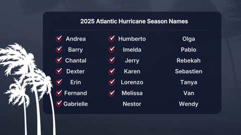
The 2025 Atlantic hurricane season names list. Those storm names used up already have check marks next to them.
Melissa is also the first storm of the season to track into the Caribbean Sea. As you can see in the season-to-date tracks map below, most other storms and hurricanes have curled north of the Caribbean Sea this season.
That’s due either to steering winds in the Atlantic, or hostile conditions for development in the Caribbean Sea prior to Melissa.
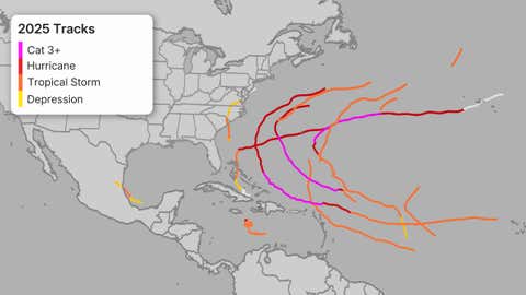
2025 Atlantic Hurricane Season Tracks To Date
Check back with us at weather.com for the latest forecast updates on Melissa, and elsewhere in the tropics.
Jonathan Erdman is a senior meteorologist at weather.com and has been covering national and international weather since 1996. Extreme and bizarre weather are his favorite topics. Reach out to him on Bluesky, X (formerly Twitter) and Facebook.
First Appeared on
Source link

