Tropical Storm Melissa not yet strengthening, but still expected to become a dangerous Caribbean hurricane » Yale Climate Connections
A Hurricane Watch is up for the south coast of Haiti and a Tropical Storm Watch for Jamaica for Tropical Storm Melissa, which had not yet strengthened as of midday Wednesday. The storm was crawling slowly west-northwestward across the near-record warm waters of the central Caribbean, which have been untouched by any hurricane or tropical storm so far this year.
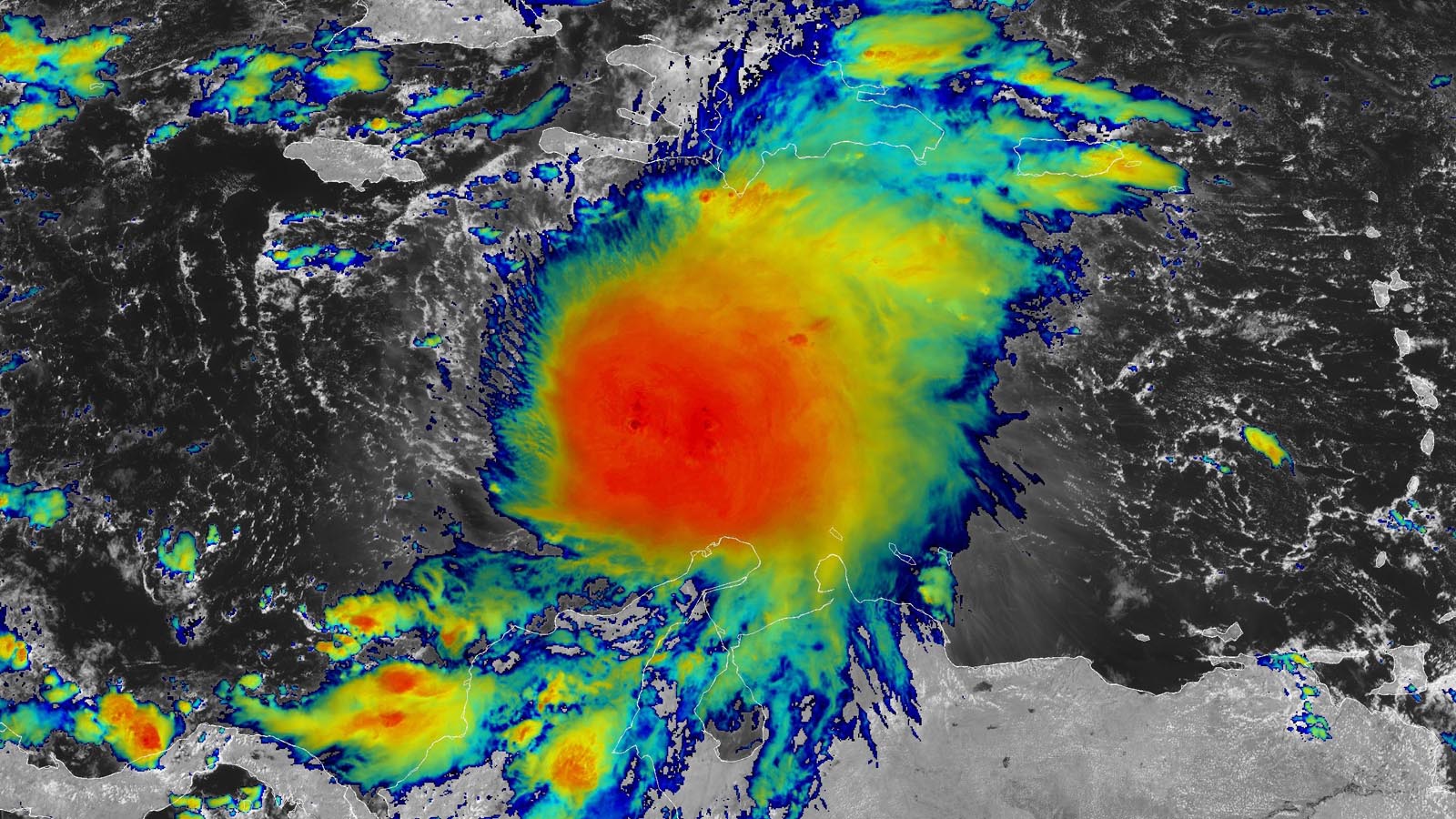
As of 11 a.m. EDT Wednesday, Melissa was located in the central Caribbean about 325 miles (525 kilometers) southeast of Kingston, Jamaica, with top sustained winds of 50 mph (85 km/hr) and a central pressure of 1,000 mb, moving west-northwest at just 2 mph (4 km/hr). Satellite images showed that high wind shear of 20-25 knots was keeping the western side of the circulation mostly devoid of heavy thunderstorms, with the storm’s heavy rains occurring over the waters south of Haiti and the Dominican Republic.
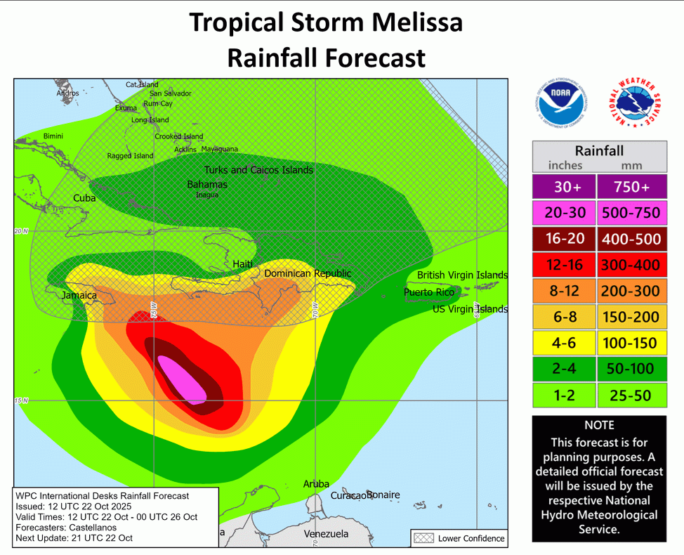
The many possibilities for Melissa’s future over the next five days include multiple days of torrential rain over some of the Caribbean’s most flood-vulnerable places. Disastrous flooding and mudslides are a threat to Haiti as well as the southern Dominican Republic, eastern Cuba, and Jamaica. Because of high wind shear from the placement of the subtropical jet stream from Florida eastward through the Bahamas, Melissa is not expected to pose any threat to the continental United States for at least the next week, and ensemble models indicate only a remote chance that the storm could end up far enough northwest to affect Florida.
Near-record-warm Caribbean waters will fuel Melissa’s growth
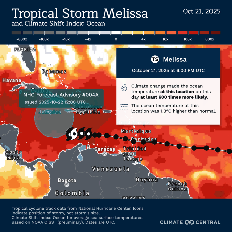
This week, Melissa will traverse some of the warmest waters ever recorded this late in the season anywhere in the Atlantic basin — near 30 degrees Celsius (86°F), about 1.3 degrees Celsius (2.3°F) warmer than average. Human-caused climate change made the current warmth near Melissa’s location in the central Caribbean about 500-700 times more likely to occur, according to Climate Central’s Climate Shift Index (Fig. 2).
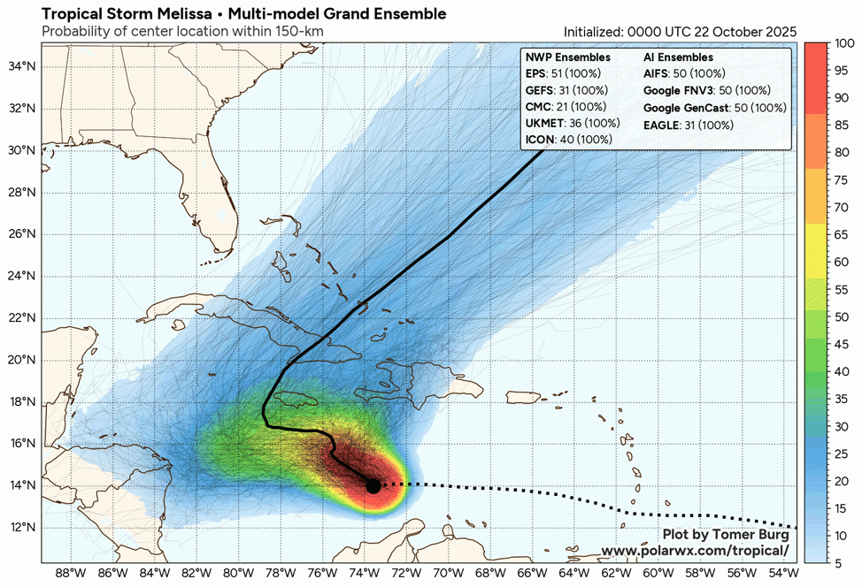
Track forecast for Melissa
There is much higher uncertainty than usual in Melissa’s track, since it is stuck in an area of weak steering currents, sandwiched between two high-pressure systems. If Melissa is able to strengthen quickly into a hurricane, its size and vertical extent would potentially allow it to feel the steering influence of a trough of low pressure over the Bahamas, tugging the storm quickly northward across Haiti or eastern Cuba and into the Bahamas by this weekend.
However, the recent trend in the models has been to keep Melissa relatively weak, which would favor a slow northwestward or westward track, keeping the system in the Caribbean through at least next Monday, Oct. 27. On this track, Melissa would have more time over warm water and would likely become a major hurricane early next week, as predicted by the National Hurricane Center in its 11 a.m. EDT Wednesday forecast. On this track, the most significant threats posed by Melissa would be to Jamaica, the Cayman Islands, and Cuba.
Intensity forecast for Melissa
Slow strengthening appears to be the best bet for Melissa over the next three days. The high wind shear affecting Melissa on Wednesday afternoon is expected to drop to a moderate 10-20 knots by Thursday and remain moderate into the weekend. The storm is embedded in an uncommonly moist atmosphere: midlevel relative humidity was near 80% on Wednesday and is expected to be 70-80% through Friday. If Melissa makes it to the western Caribbean, it may have to contend with some drier air, however.
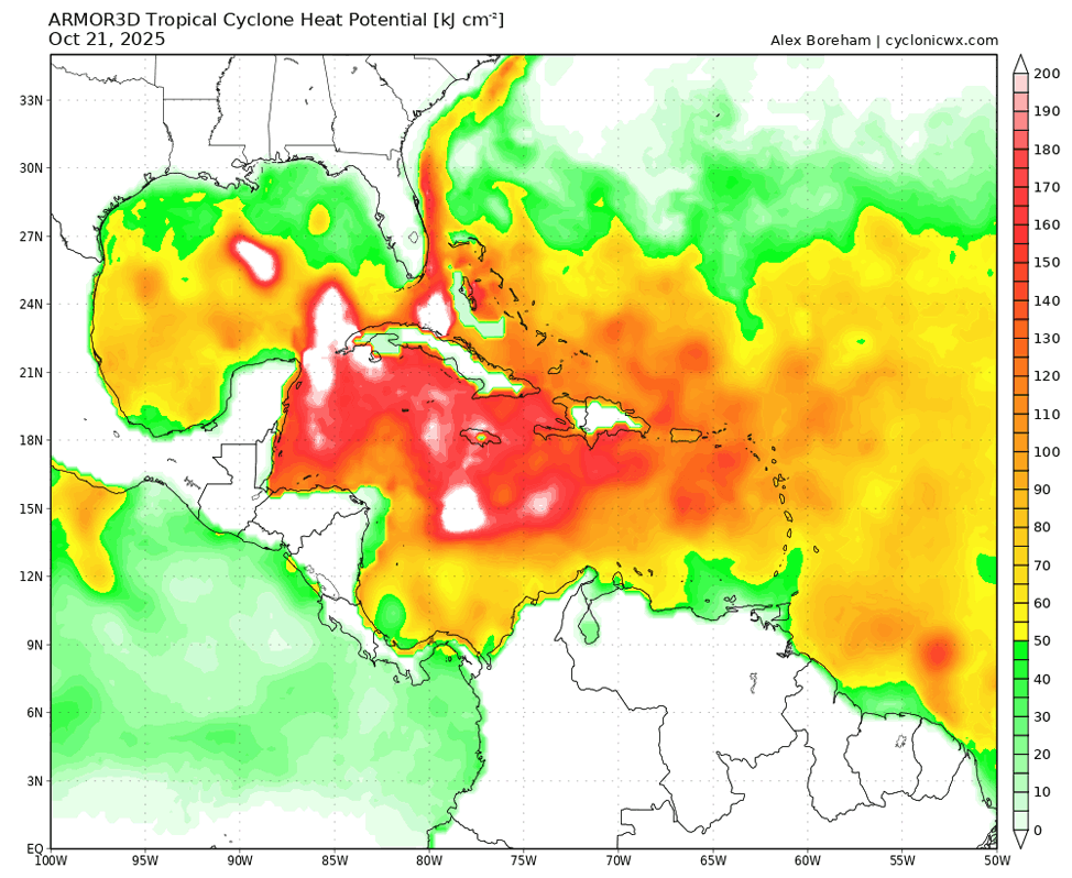
As well as unusually warm surface waters, the Caribbean has ample oceanic heat extending to a substantial depth right now (Fig. 4), so even a slow-moving Melissa is unlikely to be greatly hindered by churning up cooler subsurface water. NHC was not predicting Melissa would rapidly intensify over the next three days, but the 12Z Wednesday SHIPS model forecast called for a 15% chance of rapid intensification of 35 mph in 24 hours and a 26% chance for rapid intensification by 75 mph in 72 hours. That would put Melissa at a Category 3 strength on Saturday afternoon, with 125 mph winds.
The dangers of late-season hurricanes in the Caribbean
Slow-moving, late-season systems that gain strength in the Caribbean can cause immense trouble. In early October 2016, Hurricane Matthew moved north over far western Haiti as a Category 4 hurricane, dumping more than 20 inches (500 mm) of rain over much of far eastern Cuba and southwestern Haiti and pummeling the Bahamas and several other islands. Matthew took 731 lives and caused more than $16 billion in damage (2016 USD).
Just over 10 years ago, Hurricane Wilma strengthened with astonishing speed into a Category 5 monster in the northwest Caribbean. On Oct. 18-19, 2005, Wilma set two all-time records for the Atlantic basin for rapid intensification, as the storm deepened from 975 to 892 millibars (hPa) in 12 hours and from 979 to 882 mb in 24 hours – the latter making Wilma the strongest hurricane by central pressure in Atlantic history. Wilma also set a record for the largest 24-hour increase in top sustained winds, going from 75 to 175 mph. Wilma struck Mexico’s Yucatán Peninsula as a strong Cat 4 storm and raced northeast to strike southwest Florida on Oct. 24 at Cat 3 strength. Wilma led to 52 deaths and caused $26.5 billion in damage (2005 USD).
Near the end of October 1998, former Category 5 Hurricane Mitch dumped mammoth amounts of rain over Guatemala, Nicaragua, and Honduras (30 to 40 inches, or 750-1000 millimeters, in many areas) even as it decelerated and weakened, coming onshore at Cat 1 strength. Flooding and landslides caused some $6 billion in damage (1998 USD) and caused more than 11,000 confirmed fatalities, with another 11,000 missing people unaccounted for. Mitch was the deadliest Atlantic hurricane of the satellite-monitoring era (i.e., since the 1960s), and perhaps since the Great Hurricane of 1780.
![]()
![]()
First Appeared on
Source link

