Wintry mix tapers off, risk of slick travel lessens early Saturday morning
A slick wintry mix of freezing rain and sleet is gradually tapering off across northern Maryland and the Baltimore metro as temperatures warm just above freezing.
Risk of icy travel gradually diminishes tonight, Saturday morning
The earlier Winter Weather Advisory for Carroll, Harford, Howard, Baltimore Counties has expired.
A wintry mix of light sleet and freezing rain fell across much of northern and northeastern Maryland Friday afternoon and evening, creating slick roadway conditions in some areas. Temperatures trend slightly warmer through Saturday morning, ending the risk of icy travel in the immediate Baltimore metro. A few remaining slick spots are still possible away from the city, especially across Harford and Cecil Counties through the early morning hours.
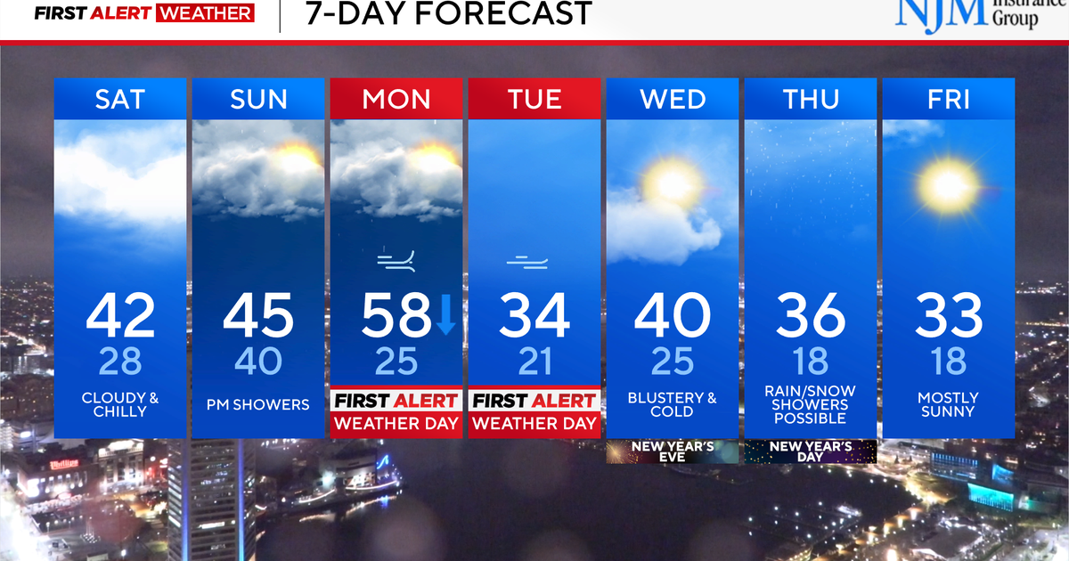
The rest of the weekend looks rather gloomy with a gray and chilly Saturday afternoon. Sunday features more clouds and a chance of scattered light rain showers. The chance of rain enters the state Sunday morning and lingers into the afternoon.
Temperatures peak in the upper 30s and 40s both afternoons.
Bitterly cold weather blows into Maryland early next week
Monday and Tuesday are First Alert Weather Days, due to crashing temperatures and a period of gusty winds.
Monday morning will likely begin breezy and unseasonably mild with temperatures near 60°. Showers will be around for the morning and midday hours. By Monday afternoon gusty winds will howl and temperatures will plummet into the 30s. Winds may gust 35 to 45 mph.
Wind and bitterly cold temperatures are likely Monday night into Tuesday. Feels like temperatures will likely drop into the single digits and teens. Winds on Tuesday may gust over 45 mph in some locations.
First Appeared on
Source link

